Is Kenya's ArdhiSasa Another Pipe Dream?

African Real Estate Blog Post has received reliable information that the much-touted Ardhisasa has opened new floodgates to corruption and land grabbing.
Our sources note that when structuring the system, the government focused on the security of the system itself by hiring IT experts from NIS and the police department, ignoring the mechanics of real estate transaction experts.
By leaving players, scholars, and other subject matter experts, the system is a chaotic impenetrable military base, where a plat map of a property and parcel number could be shown to exist on a computer in a different place from where it actually is.
Our sources indicate that officials from the Ministry of Land and members of various associations, including the Institution of Surveyors of Kenya are quietly protesting, much as they do not want to go head-on against the dreaded NIS.
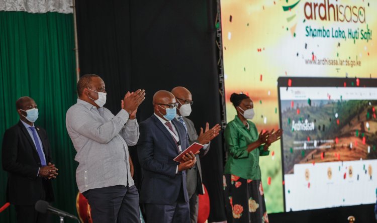
On 27th, April 2021, the government of Kenya, under the Ministry of Lands launched the National Land Information Management System, known as Ardhi Sasa.
The system launched by President Uhuru Kenyatta was to have the Lands Ministry digitize land records, streamline records of transactions and ownership. It was also intentioned to resolve land problems as it is to provide an updated, verified database of land records that are easily available.
Most importantly for Kenyans, it would reduce their trips to Ardhi House or any other lands office across the country as well as limit or remove the human element and in turn, the land cartels who have over the years used fraudulent means to harass Kenyans whenever they needed some information on their pieces of land.
However, Kenyans may have to hold on to the excitement for a while.
According to reliable sources, the system launched by the President may not be as effective as it is said to be. They reveal that while the system is well-intentioned for the common Mwananchi, the process through which the officials in charge are going about it is questionable.
It is noted that the government contracted the National Intelligence Service (NIS) to build the systems used in Ardhisasa. While the officers have technical knowledge of the systems, they are not well versed in real estate knowledge.
A vital fact that was overlooked and the impact is that the information shared on the systems is flawed. Real estate technocrats who have interacted with the system have mentioned that the systems simply bear plat maps. Meaning the maps on the systems only exist on the computer but not on the actual lands, which leaves a loophole for fraud to continue thriving on this space. The very thing that the systems were aimed at curbing.
During this year’s Mashujaa Day celebrations speech, President Kenyatta stated that the ongoing geo-referencing of land parcels will bring to an end the issuance of fake title deeds.
According to him, the exercise has so far unearthed deeply-rooted wanton illegalities including the improper allocation of government-owned parcels of land to private citizens.
“What has surprised us as we reference title deeds with geographical coordinates is the historical fraud that has existed in our land sector. We have found private land titles to roundabouts in major highways, private land titles on airport runways, and all of this is because titles were issued without reference to geographical coordinates or what experts call geo-referencing,” he stated.
Whether the intentions of the availability of ardhisasa will be achieved or not, is only left to be witnessed by the Kenyans in the years to come.
The system was rolled out in Nairobi County, Kenya, and is to roll out in subsequent counties over time.
If you have a real estate press release or any other information that you would like featured on African Real Estate Blog Post do reach out to us via email at [email protected]


